
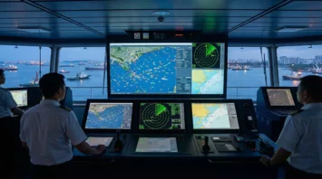
AIS systems have become a core technology for collision avoidance at sea. These tools have changed the way I keep my vessel and crew safe, giving me valuable information that helps prevent accidents. ...
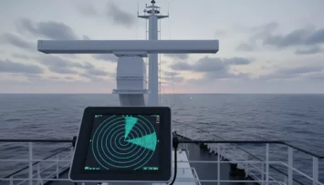
Radar technology in navigation has shaped the way vessels move across the oceans and through the skies. My experience working with navigational equipment taught me just how vital radar is, whether I’m...
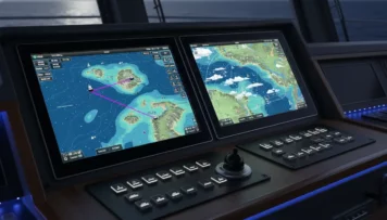
Using GPS and electronic chart display systems has totally changed how I handle navigation, especially when I’m on the water or managing large vessels. These tools bring a sense of confidence and safe...
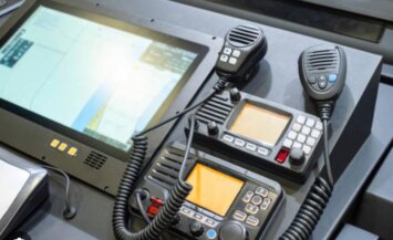
Shipboard communication makes life safer and smoother for everyone working at sea. When I step onto a ship, knowing how to send and receive information quickly and clearly matters as much as my techni...
Using a compass and charts for navigation might seem complicated at first, but learning these skills opens up a world of freedom and confidence in the outdoors or on the water. Whether I’m hiking in t...

12 responses to “How To Navigate Using A Compass And Charts”
Everyone should learn compass skills and not only on the water, but on dry land too. Technology is great, but from time to time it does glitch and then if you don’t know how to do it the old fashioned way you could get yourself into a lot of trouble.
Like anything, it takes practice, and you have offered a wonderful guide here to help us to navigate through this. I had no idea that there were so many different types of compasses to choose from. Thanks to the nautical charts, you can always see where the reefs, rocks and other obstacles are on your course.
Thank you so much for your insightful comment! ???? I completely agree — relying solely on technology can be risky, and traditional compass and navigation skills are truly invaluable, both on land and at sea. It’s amazing how much confidence you gain once you understand how to read a compass and a chart properly. I’m really glad you found the guide helpful and that it shed some light on the different types of compasses available. Safe travels and smooth sailing on all your adventures! ⛵????
This is such a clear and practical guide! As someone who’s always been a bit intimidated by traditional navigation, the step-by-step breakdown of taking a bearing and transferring it to the chart makes the process feel much more approachable.
I especially appreciated the emphasis on the importance of accounting for variation—it’s a small detail that makes all the difference between ending up where you planned and being somewhere completely different! This is a fantastic resource for both new and experienced seafarers looking to solidify their foundational skills. Thanks for sharing!
Thank you so much for your kind words! I’m really glad the guide helped make traditional navigation feel more approachable. Taking bearings can seem tricky at first, but once you get the rhythm, it becomes second nature. You’re absolutely right—accounting for variation is one of those small yet crucial details that ensures real accuracy out on the water. It’s great to hear that both new and seasoned navigators can find value in the post. I truly appreciate you taking the time to share your feedback!
This was such a clear and empowering guide, thank you! I’ve mostly relied on GPS during hikes and coastal trips, but I’ve been wanting to learn traditional navigation skills for those ‘just in case’ moments. Your breakdown of compass basics and chart reading really helped demystify things for me.
I’m curious, when you first started practicing with a compass, did you find it easier to learn on land or on water? And do you have a favorite resource or chart-reading exercise for beginners who want to build confidence before heading out?
Appreciate how you made this feel approachable and practical. I’m excited to start practicing!
Thank you so much! I’m really glad you found it helpful — that’s exactly what I was hoping for.
When I first started practicing, I found it easier to learn on land. There’s less movement to deal with, and it’s simpler to focus on understanding bearings, orienting the map, and getting a feel for how small compass errors affect direction. Once those basics felt comfortable, transferring those skills to the water felt much more natural.
For beginners, one of my favorite confidence-building exercises is to pick a few landmarks (like a hill, tree, or buoy) and practice taking bearings and plotting them on a chart or map — it’s a great way to see how compass readings translate into real-world locations.
If you’re looking for a solid resource, I’d recommend The Ultimate Navigation Manual by Lyle Brotherton — it’s clear, visual, and very practical.
Can’t wait to hear how your practice goes — it’s such a rewarding skill to build!
Great article — I really appreciate the way you break down traditional navigation into clear, practical steps. The section on combining compass and GPS especially resonated with me, since I too rely heavily on electronics but recognise the value in having a strong fallback system. I also like how you emphasise map symbols, hazards and making sure your chart is up to date. One question: when you first began practising the compass and chart method, did you find working on land easier than on water (or vice-versa), and do you have a favourite exercise you recommend for rapidly gaining confidence in this skill?
Thanks so much — I really appreciate your thoughtful feedback! You’ve picked up on exactly what I was hoping to highlight: the balance between electronic tools and traditional methods.
To your question: I actually found practising on land a bit easier at first, since it’s simpler to reference fixed landmarks and get quick feedback on bearings and distance estimates. Once I felt confident with that, transferring those skills to water made a lot more sense.
A good exercise I’d recommend is to plot short “legs” on a local map — even a park or open area — and navigate them using only your compass and a printed chart. Keep track of your estimated position, then check it against reality at each stop. It’s a great way to build both speed and intuition before applying the same method afloat.
Really glad you found the piece useful!
Navigating with a compass and charts is a timeless skill that builds confidence and safety, especially when technology fails. Learning to read map symbols, set bearings, adjust for declination, and plot routes gives you real control over your journey, whether hiking or on the water. It encourages awareness of your surroundings and helps you make smarter, more informed decisions. Overall, it’s a simple yet powerful skill that makes outdoor travel more reliable and enjoyable.
Keep up the good work!
Thank you for sharing such a thoughtful perspective! You summed it up perfectly—traditional navigation really does offer a level of confidence and situational awareness that technology alone can’t replace. Skills like setting bearings, reading symbols, and accounting for declination give you a deeper understanding of your environment and make every trip more intentional.
I’m glad the post resonated with you, and I truly appreciate the encouragement. Keeping these timeless skills alive makes every adventure safer and more rewarding.
Your article is a clear and useful guide to navigation anywhere outdoors. It was interesting that you mentioned compasses and navigational charts can be more reliable than GPS or phones. This guide certainly proves traditional navigation can be accomplished with practice, planning, and patience. Thank you for a very interesting post.
Best wishes,
Kent
Kent, thank you for the kind words — I really appreciate it. I’m glad the guide resonated with you. Even with all the convenience of GPS and phones, there’s something reassuring about knowing you can still find your way with a map, compass, and solid technique. As you said, a bit of practice and patience goes a long way toward making traditional navigation both reliable and enjoyable.
Thanks again for reading and taking the time to comment.
Best wishes to you as well!