
Plotting safe routes across international waters is one of the most important tasks for any captain or crew setting out on a long adventure.
Whether I’m moving a cargo ship, a fishing trawler, or even a private yacht, knowing how to find your way through international waters safely gives peace of mind and ensures I’m meeting local and global standards. This guide will walk you through safe maritime navigation, the tools I use, the best practices to follow, and the must know international maritime rules for safe routes.
Understanding the Basics of Safe Maritime Navigation
Safe maritime navigation depends on careful preparation and being up to date. The oceans might seem wide open, but hidden risks are everywhere, changing weather, unpredictable currents, and busy shipping lanes can make routing tricky. Whenever I plan a trip, I always factor in these variables to reduce risk for myself, my crew, and my cargo.
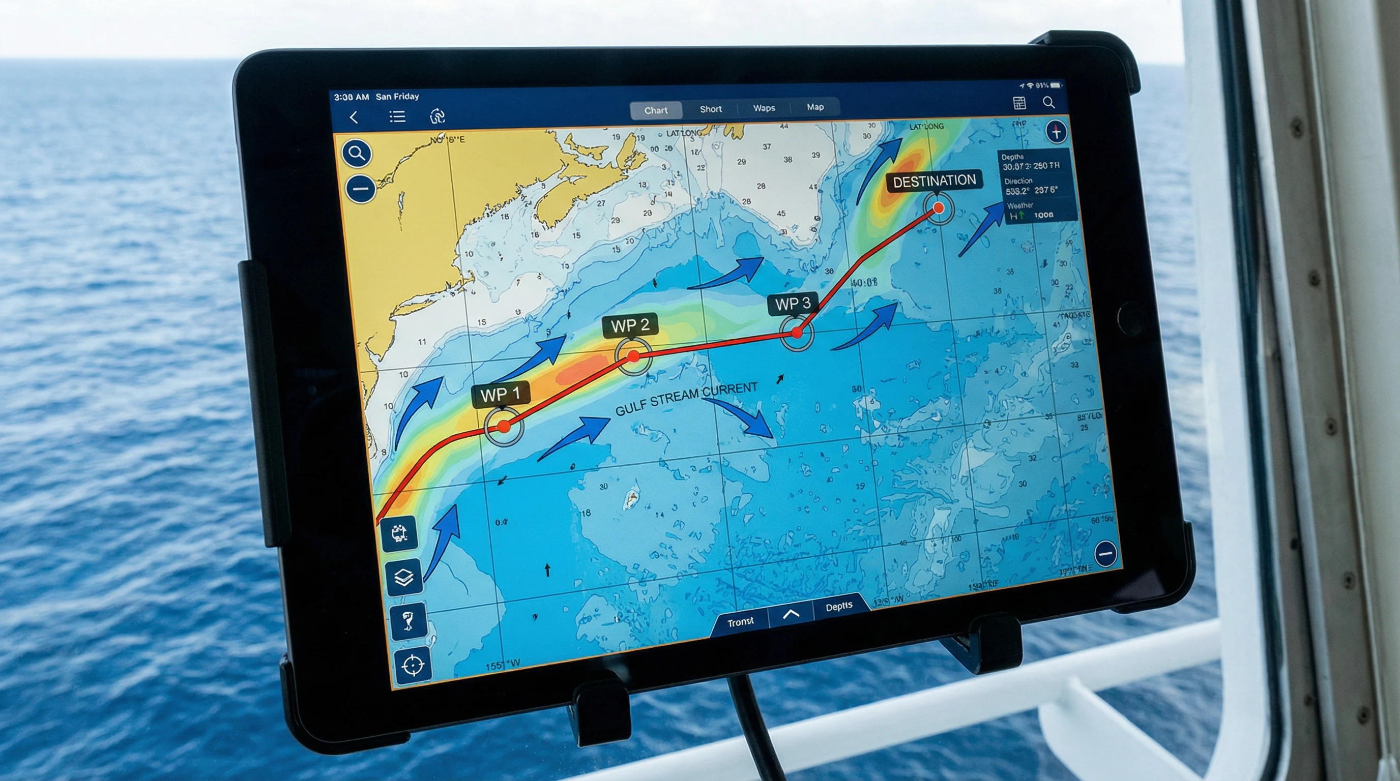
If you ask how to find your way through international waters safely, the process includes using accurate nautical charts, electronic navigation systems, and sticking to international waters safety guidelines. Technology has changed the way I plan trips, and nowadays, paper charts are often replaced by GPS based plotting tools connected to real time navigation updates for ships. These updates are especially handy if my route crosses busy straits or strategic passages known for challenging navigation.
Essential Tools and Equipment for Navigating International Waters Safely
Navigating international waters calls for specialized gear. Here’s what I depend on to keep each trip smooth:
- Electronic Chart Display and Information System (ECDIS): This digital navigation tool lets me view, plot, adjust, and monitor routes instantly. ECDIS usually comes loaded with alarms for hazards and boundary warnings.
- Global Positioning System (GPS): GPS shows me my exact location at all times, anywhere in the world, making it one of the foundations of safe maritime navigation.
- Automatic Identification System (AIS): AIS helps me spot where other ships are. This is crucial for spotting risk areas such as high traffic junctions.
- Radar: Radar detects both vessels and land, as well as large weather systems, so I can dodge collisions or unexpected detours.
- Satellite Communication Systems: These let me get up to the minute navigation updates and weather warnings. Staying connected is critical, especially when you’re far from the coastline.
Having backup power sources and keeping physical charts within reach is also wise since electronics can fail, and I want to be ready no matter what happens out there.
Planning a Safe Route: Step By Step
Plotting safe routes on the open ocean is a bit more complex than just drawing a line between two points. Here’s my go to planning process:
- Study Updated Nautical Charts: Always start with the most current charts for my planned start, destination, and any international waters along the way. Charts mark hazards, depths, established routes, and navigation buoys.
- Check International Maritime Rules for Safe Routes: My route has to respect Traffic Separation Schemes, restricted areas, Environmental Protection Areas, and other special rules laid out by organizations like the International Maritime Organization (IMO).
- Assess Environmental Hazards: I check charts and bulletins to keep an eye out for ice zones, typhoon paths, areas known for piracy, and other risk spots. Real time updates help me see what’s changing while I’m underway.
- Plan Fuel and Supply Stops: Sometimes, I pass through areas with very limited services. Planning out resupply stops and marking alternate ports helps avoid running out if things shift unexpectedly.
- Monitor Weather Predictions: I always check for storms, fog, winds, and strong currents. Modern weather routing software can improve both my safety and fuel efficiency by suggesting smart detours.
- Backup Plans and Emergency Protocols: Knowing which ports welcome emergencies, medical evacuation options, and distress communication procedures is crucial anytime something goes wrong.
Every one of these steps goes far in making my trip smoother and safer.
Key International Waters Safety Guidelines and Best Practices
International waters aren’t under the control of just one country. However, the United Nations Convention on the Law of the Sea (UNCLOS) plus IMO conventions set out basic rules. Here’s a rundown of main safety guidelines and how I put them into practice:
- Right of Way and Traffic Lanes: Always respect two-way traffic separation schemes and understand which vessel gets right of way. This cuts down collision risks, especially in packed areas like the English Channel or the Strait of Singapore.
- Speed and Watchkeeping: Safe speed is key. I ensure there’s always a lookout posted and adjust my speed for visibility or proximity to other ships.
- Reporting Positions: In busy waterways, ships often need to report their positions when going in or out. These regular updates help support safety and security for all mariners in the area.
- Security Zones: It’s essential to stay clear of military zones and follow steps near offshore facilities like oil rigs or cable stations. These are clearly listed on charts and flagged in Notices to Mariners.
- Environmental Protection: I avoid dumping anything in international waters and follow MARPOL rules on pollution. Staying safe includes making sure the ocean is protected for all living things.
Following these international waters safety guidelines doesn’t just keep my voyage safe, it helps protect oceans and those who rely on them for their work or livelihood.
Challenges in Oceanic Route Planning and How to Handle Them
Plotting safe routes isn’t always simple, there are a few common challenges I’ve run into. Here’s how I tackle each scenario:
- Shifting Weather Conditions: Squalls and storms can roll in without much warning far offshore. I plan out a couple of “safe haven” ports along my route just in case and make use of real time weather to tweak my route ahead of trouble.
- Navigation Hazards: Floating debris, icebergs, and poorly charted reefs are ongoing risks. Keeping my radar, updated charts, and a human watch means I can spot hazards sooner.
- Threats from Piracy or Security Risks: Areas such as off East Africa or Southeast Asia sometimes see piracy incidents. I take extra precautions like traveling in convoy or picking alternate routes and check advisories from organizations like the International Maritime Bureau (IMB).
- Communication Blackouts: Sometimes in polar or remote regions, satellite signals can cut out. I carry long-range radio for backup and always let someone know my planned route before departure.
- Equipment Reliability: Electronic navigation systems are a huge help, but I still keep classic tools, paper charts, compasses, and manual plotting skills in practice should electronics give out.
Taking these steps means I’m ready for whatever comes my way offshore, keeping stress lower and safety higher.
Step by Step, How I Get Ready to Find My Way Through International Waters Safely
- Review Notices to Mariners: Official bulletins let me know about channel changes, new hazards, or updates.
- Fine-tune Instruments: Before each trip, I double check my GPS, radar, and communications. If something’s off, miles from the coast isn’t the time to fix it.
- Set Waypoints: With navigation software, I mark waypoints where I turn, refuel, or pass safe harbors. This helps steer through even if a storm crops up.
- Make a Crew Briefing Plan: I take my crew through the planned route, backup options, and special notes. Everyone’s up to speed if something unusual happens.
- Keep Emergency Contacts on Hand: I prep a quick access list of ports, maritime authorities, and rescue contacts to speed up getting help if needed.
Advanced Tips for Safer Ocean Trips
After getting the basics down, these advanced tips help take ocean travel safety up a notch:
- Automated Weather Routing: Professional systems analyze current weather and suggest faster or safer alternatives. Over long haul voyages, small route tweaks can add up to major improvements in timing and safety.
- Integrated Bridge Systems: These platforms combine navigation, engine data, radar, and more, giving me a smoother overall view of my adventure in real time.
- Use NAVTEX and GMDSS: These broadcast key navigational and weather warnings. Staying tuned in keeps me ahead of hazards.
- Run Emergency Drills Regularly: Practicing drills for man overboard or fire means everyone’s ready to act fast and calm if a real emergency strikes.
Practice breeds confidence, so I always work to help my crew stay prepared and responsive.
Real-Life Examples: Why Safe Routes Matter
On a transatlantic trip, I once came across a cyclone that grew much faster than forecast. Because I’d mapped out alternate routes and refuges ahead of time, I could shift my course before things went south. Others who waited wound up stuck in rougher weather for longer.
During a crossing through the Malacca Strait, I made good use of AIS and regular position reporting. This helped me keep my distance from ships with unpredictable tracks and kept me clear of problems in busy lanes. Experiences like this strengthen my belief in plotting safe routes every time I go offshore.

Frequently Asked Questions About Navigating International Waters Safely
Question: What is the best way to stay updated on hazards and route changes as they happen?
Answer: I use a combination of satellite communications, NAVTEX broadcasts, and software that delivers real time updates. Subscribing to bulletins from trusted maritime authorities keeps my information fresh and reliable.
Question: How can I double-check that I’m following the rules for international maritime routes?
Answer: A good practice is to use the International Maritime Organization (IMO) website, local government advisories, and up to date charts. These resources spell out exactly what is needed for different zones.
Question: Are electronic charts always better than paper?
Answer: Electronic charts are convenient and come with ongoing updates, but I still keep paper charts stowed away for backup. If electronics go down or lose signal, old school methods remain a lifesaver.
Question: What should I do if I see pirates or something suspicious?
Answer: Try to boost your speed and turn away. After that, follow the set protocols for the region. This usually means contacting maritime authorities and sending out an alert to nearby vessels. Doing your homework on high risk areas and staying tuned in can make a big difference.
Picking the Right Tools and Practicing Smart Habits
Using reliable navigation gear and learning sound habits lets me plan safe routes and follow international waters safety basics on every trip. Equipment like ECDIS, GPS, and satellite weather updates are the backbone of successful long-range journeys. Building good habits, such as frequent position checks, regular crew briefings, and steady monitoring of official notices keeps risk in check, even thousands of miles offshore.
Every vessel and trip brings something new, but staying focused on safe maritime navigation, using up to date tools, following international maritime rules for safe routes, and prepping thoroughly helps me keep each adventure running smoothly and enjoyably as I cross international waters.


Your step-by-step breakdown of planning a safe route really stood out to me. It’s easy to imagine navigation as just plotting a straight line, but you showed how much more goes into ensuring safety—like checking maritime rules, monitoring hazards, and preparing backup plans.
I especially appreciated the reminder about planning fuel and supply stops; it’s such a practical detail that could make all the difference in an emergency.
Do you think modern weather-routing software is now the most reliable tool in this process, or do traditional charts still play a more significant role when conditions become unpredictable?
Thank you — I’m really glad the breakdown resonated with you! You’re absolutely right: navigation is so much more than drawing a line on a chart. It’s the layers of preparation and awareness that make a route truly safe.
As for weather-routing software vs. traditional charts, I’d say they both have important roles:
Modern weather-routing software is incredibly powerful — it can process real-time data, forecast patterns, and suggest optimal routes faster than any human could. For planning efficiency and staying ahead of developing systems, it’s an amazing tool.
But when conditions turn unpredictable, traditional charts and manual skills still matter.
Electronics can fail, signals can drop, and automated routing can’t always account for local judgment, on-the-spot observations, or sudden anomalies. Charts give you situational awareness at a level software can’t fully replace, especially in tight coastal areas or when you need to improvise safely.
So the most reliable approach is a blend:
Use modern software for planning and forecasting, but rely on traditional charts and seamanship to validate, interpret, and adapt when reality doesn’t match the screen
Hi there –
Traversing the high seas can be daunting, especially for novice sailors. This blog provides a comprehensive guide to prepare for the journey. Informing friends and family about the route you will be taking can be overlooked but it is important. What’s more, GPS and navigation systems are now commonplace and are reliable. Having back-up physical charts in case of a failure is wise. These are great tips to ensure any trip is smooth.
Again, this is fantastic guide for navigating international waters whether you are embarking on your first journey or experienced.
Thank you for the thoughtful feedback!
You’re absolutely right — even with today’s tech, letting others know your route and keeping physical charts on hand are simple steps that can make a huge difference out on the water. Sailing can feel overwhelming at first, so I’m glad the guide helped highlight those essentials for both new and seasoned sailors.
Really appreciate you taking the time to share your insights!